


AlbertHerring-b4cc6b5cfb.jpg)


Saving Pumpkin Ash Trees

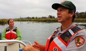
FODM and the National Park Service (NPS) have undertaken a project to save some of the preserve's pumpkin ash trees (Fraxinus profunda) from the emerald ash borer (EAB) (Agrilus planipennis), an invasive insect that has been documented in Northern Virginia and will kill all species of ash trees, according to U.S. Department of Agriculture experts.
Another Step Toward Restoration
On September 28-29, 2015, National Park Service (NPS) and U.S. Army Corps of Engineers (COE) officials met to begin the design of the restoration of Dyke Marsh under a NPS-COE interagency agreement. Officials estimate the design phase will take at least 12 months.
Reaching Out at Earth Sangha

On September 27, 2015, the Friends of Dyke Marsh had a table offering Dyke Marsh information at Earth Sangha's semi-annual native plant sale held at their garden in Springfield. We participated alongside other groups, including the Friends of Huntley Meadows, the Friends of Accotink Creek and the Arlington Master Naturalists.
Ecological Society of America Visits DMWP
 Dr. Guajardo
On the lovely, warm, sunny day of August 8, 2015, I led 19 ecology students and professional ecologists and one child for a too-abbreviated visit to the Dyke Marsh Wildlife Preserve (DMWP), as part of the special 100th anniversary meeting of the Ecological Society of America being held at the Baltimore Convention Center.
FODMers Learn about Pollinators
Pollinators visit flowers for nectar and pollen and when visiting flowers, they move pollen from one flower to another of the same species to produce fertile seeds. Most flowering plants are pollinated by bats, bees, butterflies, flies, beetles, and other animals. Plants can also be pollinated by wind and water and self-pollinate.
Animal pollinators face many challenges, including pollution, pesticides, habitat loss, invasive plants, disease, parasites and climate change.
International Attention to Dyke Marsh
 On April 14, 2015, FODM and the National Park Service led a group of Iraqi officials and scientists on a walking tour of Dyke Marsh. FODM is honored to have had these visitors. FODM president Glenda Booth has written an article that was published in the April 22, 2015 Mount Vernon Voice newspaper. Click here to view the photos and read the entire article.
$25 Million to Restore Dyke Marsh
 Secretary Jewell
U.S. Secretary of Interior Sally Jewell on October 24 announced a grant of $25 million to the National Park Service to restore Dyke Marsh, which is eroding six to eight feet a year. The funds are part of the Obama Administration's Hurricane Sandy Rebuilding Strategy and Climate Action Plan to build resilience by restoring natural features along shorelines and protect communities from future storms.
Dyke Marsh restoration is one of 25 projects that DOI selected for funding out of 94 submitted.
Click here for a video of Secretary Jewell's visit to Dyke Marsh.
Dyke Marsh Gets TV and Online Recognition
Producers of This American Land chose the Dyke Marsh Wildlife Preserve as one of America's little known but special places. We agree. View a video of it.
Ospreys Star
 Osprey nest
"Our" osprey pair at the Belle Haven marina boat ramp is featured in a 13-minute video titled "Osprey Love Nest." William Young, an Arlington writer, shot the footage and wrote the script. Ashley Bradford, an artist who lives near Dyke Marsh, does the narration. The video provides information about the behavior, anatomy and field marks of the nesting pair, as well as their interactions with other birds in the marina.
He has shot other videos featuring egrets, coots and earned and horned grebes in the area which are on his page.
Beaver Activity in Western Dyke Marsh
 Beaver Activity in Western Dyke Marsh
FODMer Laura Sebastianelli is monitoring beavers in the western part of Dyke Marsh, behind River Towers. On May 1, she spotted two families, two adults and a kit and two adults and two kits nursing. At one point, she saw five adults and three kits on top of the lodge and at least one beaver swimming around. Thank you, Laura. This is a very special, little-visited part of Dyke Marsh.
Girl Scout Troop 2459 Tackled Trash at Dyke Marsh
 Ten enthusiastic Girl Scouts from Troop 2459 visited the Dyke Marsh Wildlife Preserve on April 28, 2015 and cleaned up trash along the shoreline. They are working on an animal habitat badge. Their
  troop leader is Sarah Olson and they are based at Fort Hunt Elementary School in the Mount Vernon area. FODM President Glenda Booth, Vice President Ned Stone and FODMer Patty McCarthy talked about the harm of trash on wildlife and habitat.
FODM Participated in Gum Springs Community Day
 FODM Vice-President Ned Stone helps a youngster make a bird.On June 20, 2015, the Friends of Dyke Marsh spread the news about the Dyke Marsh Wildlife Preserve to new friends and old at the annual Gum Springs Community Day. Gum Springs is a historic community in the Mount Vernon area of Fairfax County founded by West Ford, a freed slave, in 1833.
 FODMers joined others in a "hats off" salute to the Fairfax County Police.

 Friends of Dyke Marsh, Inc. is a non-profit 501(c)(3) organization.