New Buoys Mark River Boundaries
By Erik Oberg, Biologist, NPS
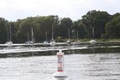
 Buoy at the Belle Haven Marina. Photo by NPS.On September 27, NPS's Natural Resources and Lands staff marked Dyke Marsh's federal boundary in the Potomac River with 11 buoys. This marks the end of four years of work to secure the approvals, permits and funding to help visitors see and understand the full extent of Dyke Marsh and how much land has eroded since the NPS began managing the marsh.
Working as a team, park staff safely moved and set over 3,300 pounds of concrete anchors, buoys and chain. With excellent satellite reception, anchors were placed within 17 inches of the target for every location. Each anchor was given enough chain to allow for site-specific water depth, anchor sinkage, tide and peak flood variation.
In addition to placing all 11 boundary buoys, NPS staff also gave assistance to U.S. Geological Survey researchers by extracting three soil cores from the marsh. These cores will be analyzed to provide a millennium-scale climate record of the region and supplement a new joint publication.

 Friends of Dyke Marsh, Inc. is a non-profit 501(c)(3) organization.